


track

boudatadec
User
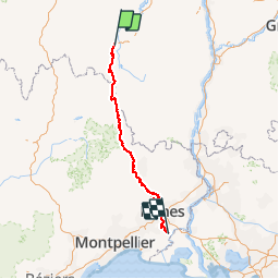

Length
237 km

Max alt
1237 m

Uphill gradient
4407 m
Km-Effort
298 km

Min alt
8 m

Downhill gradient
5037 m
Boucle
No
Creation date :
2018-06-26 16:57:09.124
Updated on :
2018-06-26 16:57:09.124
--
Difficulty : Very difficult

FREE GPS app for hiking
 SityTrail
IGN / Geographical institutes
SityTrail Plus
The world is yours!
About
Trail Walking of 237 km to be discovered at Auvergne-Rhône-Alpes, Haute-Loire, Le Puy-en-Velay. This trail is proposed by boudatadec.
Positioning
Country:
France
Region :
Auvergne-Rhône-Alpes
Department/Province :
Haute-Loire
Municipality :
Le Puy-en-Velay
Location:
Unknown
Start:(Dec)
Start:(UTM)
569403 ; 4988293 (31T) N.
Comments